
Monday, December 9, 2013


Monday, December 2, 2013

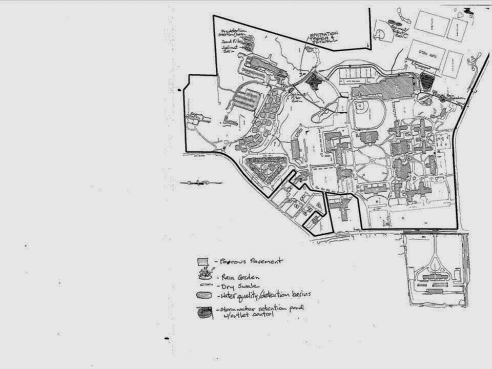
First draft of Map

Tuesday, November 5, 2013
Wednesday, October 30, 2013


Thursday, October 24, 2013
Map Proposal
Mapping the Green Infrastructure on the campus of Siena
College.
Jason Appleby
Siena College
515 Loudon Rd
Loudonville, NY 12211
Introduction
In recent years with the rise of global warming, and the deterioration
of our ozone layer, humans have turned to a more sustainable way of thinking
and living. In turn this started a green movement. A sustainable lifestyle that attempts to
reduce an individual or society’s use of the Earth’s natural resources and
personal resources. As a way to reduce
their carbon footprint and help with Earth’s natural ecology and cycles. As a
result of this movement, Siena College has attempted to adjust and change with
the times that we now live in. Working with John McPhee Assistant Director of
Architecture and Engineering here at Siena College, we will develop a GIS model
of the campus and the green infrastructure located within the grounds.
Objectives
This project will map out green infrastructure on Siena
College grounds, such as:
·
Porous Pavement
·
Retention Basins
·
Rain Garden
·
Water Quality Basins
·
Dry Swales
·
Cool Roofs
·
Dry Wells
·
Wetlands
·
Irrigation wells
·
Retention ponds
Methodology
With this GIS analysis will use past plan from architect
firms that have helped Siena College move in this direction of sustainability.
With past campus projects Siena has made choices to move in the direction of
sustainability, over the years these changes have happened slowly. At this time
we will compile all past data to create a GIS database displaying all of these
green infrastructure changes, in a PDF format style map.
Data Sources
Past blue prints
Past surveys of campus
On site verification
Work Plan
Week 1 - Talk with John McPhee - set up plan. Create proposal.
Week 2 - Map out areas on Campus that falls into Green Category. Create first draft of Map
Week 3 - Continue creating first draft of Map, review with John.
Week 4 - Verify first draft, start working on second and/ or final draft.
Deliverables
Week 2 - Map out areas on Campus that falls into Green Category. Create first draft of Map
Week 3 - Continue creating first draft of Map, review with John.
Week 4 - Verify first draft, start working on second and/ or final draft.
Deliverables
- Test Aerial photo against lastest satellite imagery to see which is more up to date. Whichever is more up to date is the foundation of which I will build the map.
- Data will be captured from survey data received from architect firms that have done work on campus
- A PDF map will be the final product.
- As a co-worker I catch up to John periodically through the week to update him on progress or ask questions on the direction of the project.
- Weekly or bi-weekly I will post the latest draft of the map to the blog.
Subscribe to:
Posts (Atom)